


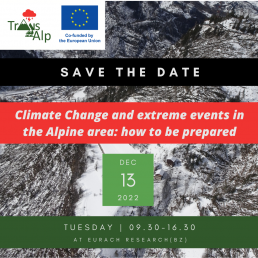
Internationale konferenz: "Klimawandel und Extremereignisse in Alpenraum: Wie man sichvorbereiten kann"
Der Termin für die Abschlussveranstaltung rückt näher!
Die internationale Konferenz findet statt in Bozen (Italien) von 9.30 bis 16.30 Uhr
Die Sitzung wird auf ENGLISCH, DEUTSCH und ITALIENISCH abgehalten
Weitere Informationen und Anmeldung auf der Website der Konferenz
https://project-transalp.eu/international-conference
Trans-Alp Project in the magazine RETICULA!
The Trans-Alp project is featured in the 30/2022 issue of the prestigious magazine RETICULA by ISPRA!
To read the magazine, please CLICK HERE
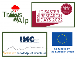
Two conferences to present the project's results
The project partners in the upcoming days, will present their research results at two major events :the "International Mountain Conference," which will be held on September 11-15, and Disaster Research Days 2022, which will instead take place on October 13-14. Both the events will be held at the University of Innsbruck (Austria) and will be an important opportunity for experts and authorities, to discuss the various issues related to preventing disasters and building systems that are resistant and resilient to new challenges related to climate change in the mountain regions.
Below are links to the schedules for the two events
https://www.dcna.at/index.php/en/disaster-research-days-2022.html
International Mountain Conference
https://www.imc2022.info/final-schedule/
International Workshop - Video now available
The video and materials of the international Workshop “FACING TRANSBOUNDARY EXTREME EVENTS IN ALPINE REGIONS UNDER CLIMATE CHANGE: CHALLENGES AND PERSPECTIVES” are now available at this link.
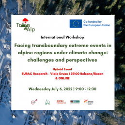
International Workshop - Facing Transboundary Extreme Events In Alpine Regions Under Climate Change: Challenges And Perspectives
The International Workshop “FACING TRANSBOUNDARY EXTREME EVENTS IN ALPINE REGIONS UNDER CLIMATE CHANGE: CHALLENGES AND PERSPECTIVES” will be held Wednesday July 6th, 2022 from 9 to 12:30 at EURAC Research, viale Druso 1, 39100 Bolzano/Bozen and also ONLINE.
The event will provide a brief overview of the activities and preliminary results of the TRANS-ALP project, with the aim to foster an interdisciplinary discussion on current and perspective risks related to extreme hydrometeorological events.
The workshop is aimed at Civil Protection authorities, Decision Makers, Risk practitioners from alpine region and other areas, as well as at partners and observers of projects working on similar topics.
The participation is free of charge but we kindly ask the participants to register for organizational purpose until Friday, July 1st, 2022.
Free registration here: https://forms.gle/a2BdfvuPP5FrscB27
Here below the link for remote connection, we will use Zoom platform:
https://scientificnet.zoom.us/j/92217588334?pwd=V3hLWGRhcmlJa2xlNHRDc2JxdU5DQT09
![]()
Veröffentlichung in der italienischen Wochenzeitschrift "Ambiente Informa"
In der Wochenzeitung „Ambiente informa“, dem Newsletter des Nationalen Systems zum Schutz der Umwelt (SNPA), wurde ein Artikel veröffentlicht, der über die Zusammenarbeit von Arpa Veneto im Trans-Alp-Projekt zur Verbesserung des Risikomanagements bei Bergstürmen spricht
Der Artikel ist auf Italienisch unter DIESEM LINK verfügbar und spricht über die Ergebnisse des Projekts ein Jahr nach Beginn der Aktivitäten
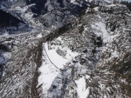
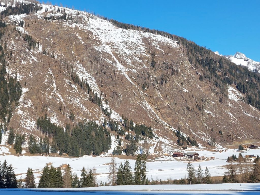
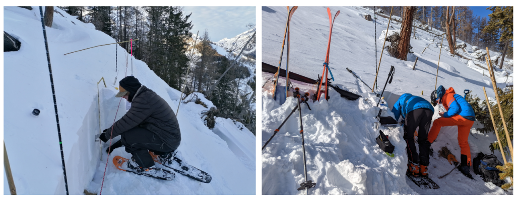
Trans-Alp field campaign at windstorm damaged forest
Trans-Alp field campaign at windstorm damaged forest slopes with susceptibility of future multi-hazard cascading effects in the pilot region of Easttyrol
Already in the inital phase of the Trans-Alp project, the BFW contributors focused on the area of Easttyrol (a large district of the federal state Tyrol), where the severe storm VAIA (Oct. 2018) destroyed thousands of hectares of protection forests which led to about 500.000 cubic meters of damaged timber. The windthrown and mostly immediately cleaned areas are often representing steep and inaccessible slopes close above settlements or transportation routes. At some spots, responsible actors have to count with “post-storm-cascading-effects” like landslides and avalanches because of the establishment of new release areas. This fact fits properly to the topic of T3.3 “Analyses of cascading effects of storm related land cover change” which is part of the work package WP3 “Approaches and Methodologies for Storm Damage and Loss Observation and Mapping”.
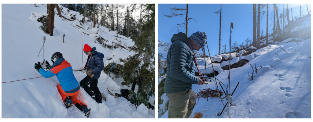
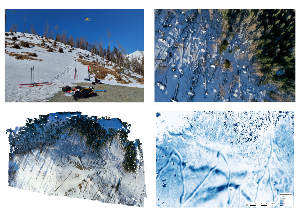
For the field campaign, one of the severely affected spots in the community of Kals am Großglockner was chosen. The campaign mainly focusses on snow distribution / snow cover formation and which effect the roughness of unmanaged windthrow areas has with regard to avalanche formation. A long-term goal is to observe the degradation of roughness over time from these unmanaged windthrow areas.
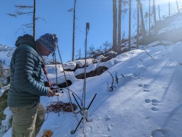
The core concept is, to examine areas in sustained forested stands, uncleaned windthrown stands (deadwood) and cleaned forest stands respectively open land. Substantial differences with regard to snow cover formation and subsequently avalanche formation are expected. The used methods include measurements with the SnowMicroPen (electric probe, developed by the SLF), drone-based photogrammetry and the recording of snow profiles. With the SnowMicroPen, the complex stratification of the snow cover (penetration resistances) and its spatial variability can be measured. This has already been done on several transects in differently vegetated terrain. The recording of snow profiles serves, among other things, as validation of the points measured with the SnowMicroPen. Drones are used to obtain a comprehensive overview of snow depth. These deliver extensive image data, which is compiled into an accurate 3D model in a complex post-processing process using point clouds. In this way, the snow depth and distribution can be observed over time and validated with the snow profiles or manual depth measurements.
Based on this examination procedures, we want to contribute to a better understanding of the formation and build-up of snow cover on storm-damaged forest areas. The overarching goal is to better assess the potentially developing multi hazard and cascading effects. In addition, the applied work processes in the frame of this field campaigns are described within the framework of deliverable 3.3 in the form of a work procedure manual and guidelines.
ARPAV - The TRANS-ALP project results in the first year of activity
The increasing intensity and frequency of extreme weather events in the Mediterranean region, presumably linked to climate change, threaten the most vulnerable environmental and socio-economic systems. Arpa Veneto, with the regional department for territorial security, is involved in an ambitious European project, TRANS-ALP, funded by the European Union program for prevention and
preparation in the field of civil protection and marine pollution. The overall objective of the project is to develop an integrated methodology for the multi-risk assessment following extreme weather phenomena and the prediction of their impact for mountainous regions on a cross-border scale, in order to further advance decision-making processes and support the transnational cooperation in the European Union during the natural disaster management cycle. The Austrian Central Institute of Meteorology and Geodynamics – ZAMG, the Austrian Forest Research Institute – BFW and the Vicenza-based European Project Consulting – EPC are partners of Trans-Alp.
The main results presented to the European Union in the first year of activity
Arpa Veneto in the first year of the project focused on the critical review of various multi-risk assessment methodologies used in the countries of the Alpine arc, to try to provide a conceptual methodology integrated into the management cycle of natural disasters.
Trigger rainwater thresholds.
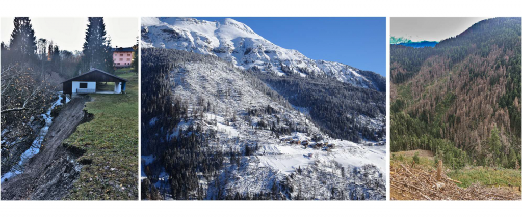
Due to the high energy of the relief, due to its morphology and the various geological fragilities associated with the structure of the mountains, the alpine environment is subject to frequent instability phenomena such as landslides, avalanches and torrential floods. The experience of Arpa Veneto, gained in recent decades in civil protection procedures, has led to the awareness that an effective way to mitigate the hydrogeological risk is to improve the warning system based on triggering rain thresholds. As the studies of the scientific community in this sector show, in order to identify reliable rainfall thresholds it is necessary to know a considerable number of historical instability events such as to guarantee a solid statistical basis representative of the meteorological phenomenon. The databases a b c present on the national territory to date, first of all the Inventory of Italian Landslide Phenomena – IFFI, are rich in information on the correct location of landslides, but there is very little information relating to when these occurred, thus making the work of restitution of rainfall thresholds particularly difficult to carry out. In the TRANS-ALP project, a methodology that could overcome this limit was therefore developed and proposed to the Civil Protection System of the European Union. The proposed method, easy to apply, is based on the statistical analysis of the rainfall recorded by the automatic stations since they were installed in the mid-1980s. Once the maximum daily precipitation has been identified, the values relating to the days in which precipitation was recorded equal to the 99th percentile with respect to the maximum precipitation are extrapolated. Having identified the potentially critical dates, the technicians of Arpa Veneto searched for possible effects on the ground in the historical archives of newspapers, in the reports of the Fire Brigade, in the technical reports of research and municipalities.
The results were encouraging, especially as regards the instability that responds to persistent rainfall characteristic of the autumn and winter seasons. The procedure led to the identification of numerous failures that were already known, but that had never been associated with a specific date in any official database. By expanding and refining the methodology, the number of reported damage events increased up to a significant number in order to statistically analyze rainfall, with the aim of identifying representative trigger thresholds for a given area.
Data collection on natural disasters and webgis.
In collaboration with the other project partners, Arpa Veneto conducted a critical analysis of how the various administrations responsible for collecting data relating to natural disasters operate in their respective countries. What has emerged is a great heterogeneity, at European level, in the management of these data. Among the few aspects that the different databases have in common is the use of webGIS generally open to the public for data sharing. Nevertheless, the webGIS themselves are organized in a non-uniform way in the representation of the data and hardly contain information on events that occurred before their publication. A virtuous example in this sense is the webGIS avalanche officially presented by the Avalanche Center of Arabba of Arpa Veneto in 2021.
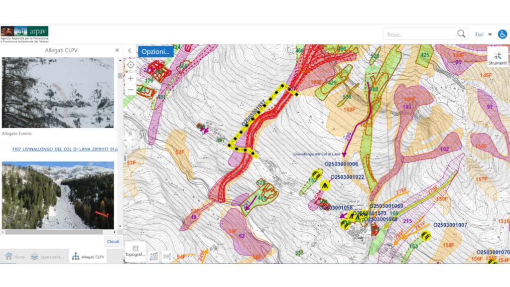
In fact, all the data relating to the constantly updated avalanche location map, the cadastre of the defense works, the Plans of the Areas Exposed to Avalanches and the technical reports with attached photographs of all the avalanche phenomena recorded by the technicians converge in the database of the Avalanche Center in over 30 years of activity. The report analyzed all the management and representation systems of data relating to natural disasters and highlighted the strengths and weaknesses of each system. Finally, guidelines were proposed for the collection and management of data in order to provide the member countries of the European Union with a methodology that is as uniform as possible also for easier sharing of information. The guidelines range from indications on the reference systems to be adopted during mapping, to the type of data to be recorded, but above all they contain the proposal to establish a common European-wide database of disasters connected to intense meteorological events. The TRANS-ALP project is, in fact,
focused on classifying the danger of what are defined chain effects resulting from intense meteorological phenomena. The VAIA storm certainly taught a lot in this sense: the mapping of landslides and flooded areas carried out close to the event was certainly not exhaustive of the effects on the ground that would have been recorded in subsequent years. In fact, the felled trees have generated numerous new avalanche sites, in many cases insisting on vulnerable elements such as houses and infrastructures. Just as the trees left on the ground in order to mitigate the avalanche risk up to the completion of the defense works have increased the risk of proliferation of the Spruce Bark beetle. In the coming weeks, an example of multi-risk classification that takes into account all the phenomena that may occur as a consequence of a storm will be published on the TRANS-ALP website, thanks to a webGIS viewer. Thanks to the experience of the EURAC research center gained in this sector, the above has been further represented thanks to the conceptual model of the impact chain methodology consisting of a multi-risk analysis model capable of describing the cause-effect relationship between all factors that constitute the vulnerability of a system and analyze the climatic signals that can lead to an increase in risk. The model is a useful analysis tool for the civil protection system.

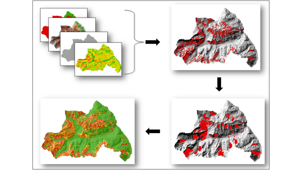
Simulation model of post-extreme instability.
Finally, a geostatistical model was developed by the technicians of Arpa Veneto capable of simulating the propensity for instability following an event, such as that of VAIA, capable of upsetting the morphological and forest cover balances of a given territory. The model, taking into account all the morphological characteristics and vegetation cover, thanks to a specific algorithm, returns the probability of triggering of an avalanche phenomenon. Once the trigger areas have been identified, the model automatically processes the release of avalanches and calculates their trajectory on a morphological basis, also indicating which vulnerable elements may be affected by the avalanche transit. This easy-to-use tool will be of great use in the first civil protection actions following the meteorological event, in order to identify intervention priorities for risk mitigation.
Next Steps
Before the end of the project, the technicians of Arpa Veneto will develop a mathematical elaboration model capable of returning, following events such as VAIA, the height values of the vegetation falled to the ground. The trees falled to the ground constitute, in fact, a first protection against the possibility of triggering of avalanches, therefore capable of mitigating the risk until the defense works are carried out; it is essential to know its height to understand how much snow must accumulate on the ground before creating a real problem for the towns below. This value then becomes the starting point in the application of the various civil protection procedures still in place today in the territories affected by VAIA. At the end of the project, an integrated tool will therefore be available capable of returning a multi-risk scenario following extreme meteorological phenomena and, at the same time, of providing tools of immediate use to support civil protection operations and procedures.

CoupEvent project workshop: Hillslope-channel coupling during extreme events
The final workshop of the project CoupEvent: Hillslope-channel coupling during extreme events will take place online on February 14th, 2022. The project has focused on interconnections among mass wasting processes and channel dynamic during extreme events in South Tyrol, a paradigmatic mountain region.
Massimiliano Pittore, the TRAN-ALP Project Manager, will present to the audience the TRANS-ALP project goals, outputs, activities and the project interdisciplinary approach.
More information about the event at this link: https://www.eurac.edu/en/institutes-centers/institute-for-earth-observation/news-events/coupevent-final-workshop