


ARPAV - The TRANS-ALP project results in the first year of activity
The increasing intensity and frequency of extreme weather events in the Mediterranean region, presumably linked to climate change, threaten the most vulnerable environmental and socio-economic systems. Arpa Veneto, with the regional department for territorial security, is involved in an ambitious European project, TRANS-ALP, funded by the European Union program for prevention and
preparation in the field of civil protection and marine pollution. The overall objective of the project is to develop an integrated methodology for the multi-risk assessment following extreme weather phenomena and the prediction of their impact for mountainous regions on a cross-border scale, in order to further advance decision-making processes and support the transnational cooperation in the European Union during the natural disaster management cycle. The Austrian Central Institute of Meteorology and Geodynamics - ZAMG, the Austrian Forest Research Institute - BFW and the Vicenza-based European Project Consulting - EPC are partners of Trans-Alp.
The main results presented to the European Union in the first year of activity
Arpa Veneto in the first year of the project focused on the critical review of various multi-risk assessment methodologies used in the countries of the Alpine arc, to try to provide a conceptual methodology integrated into the management cycle of natural disasters.
Trigger rainwater thresholds.
Due to the high energy of the relief, due to its morphology and the various geological fragilities associated with the structure of the mountains, the alpine environment is subject to frequent instability phenomena such as landslides, avalanches and torrential floods. The experience of Arpa Veneto, gained in recent decades in civil protection procedures, has led to the awareness that an effective way to mitigate the hydrogeological risk is to improve the warning system based on triggering rain thresholds. As the studies of the scientific community in this sector show, in order to identify reliable rainfall thresholds it is necessary to know a considerable number of historical instability events such as to guarantee a solid statistical basis representative of the meteorological phenomenon. The databases a b c present on the national territory to date, first of all the Inventory of Italian Landslide Phenomena - IFFI, are rich in information on the correct location of landslides, but there is very little information relating to when these occurred, thus making the work of restitution of rainfall thresholds particularly difficult to carry out. In the TRANS-ALP project, a methodology that could overcome this limit was therefore developed and proposed to the Civil Protection System of the European Union. The proposed method, easy to apply, is based on the statistical analysis of the rainfall recorded by the automatic stations since they were installed in the mid-1980s. Once the maximum daily precipitation has been identified, the values relating to the days in which precipitation was recorded equal to the 99th percentile with respect to the maximum precipitation are extrapolated. Having identified the potentially critical dates, the technicians of Arpa Veneto searched for possible effects on the ground in the historical archives of newspapers, in the reports of the Fire Brigade, in the technical reports of research and municipalities.
The results were encouraging, especially as regards the instability that responds to persistent rainfall characteristic of the autumn and winter seasons. The procedure led to the identification of numerous failures that were already known, but that had never been associated with a specific date in any official database. By expanding and refining the methodology, the number of reported damage events increased up to a significant number in order to statistically analyze rainfall, with the aim of identifying representative trigger thresholds for a given area.
Data collection on natural disasters and webgis.
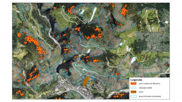
In collaboration with the other project partners, Arpa Veneto conducted a critical analysis of how the various administrations responsible for collecting data relating to natural disasters operate in their respective countries. What has emerged is a great heterogeneity, at European level, in the management of these data. Among the few aspects that the different databases have in common is the use of webGIS generally open to the public for data sharing. Nevertheless, the webGIS themselves are organized in a non-uniform way in the representation of the data and hardly contain information on events that occurred before their publication. A virtuous example in this sense is the webGIS avalanche officially presented by the Avalanche Center of Arabba of Arpa Veneto in 2021.
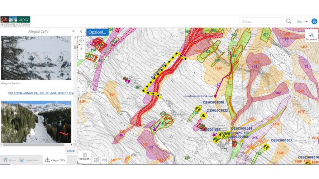
In fact, all the data relating to the constantly updated avalanche location map, the cadastre of the defense works, the Plans of the Areas Exposed to Avalanches and the technical reports with attached photographs of all the avalanche phenomena recorded by the technicians converge in the database of the Avalanche Center in over 30 years of activity. The report analyzed all the management and representation systems of data relating to natural disasters and highlighted the strengths and weaknesses of each system. Finally, guidelines were proposed for the collection and management of data in order to provide the member countries of the European Union with a methodology that is as uniform as possible also for easier sharing of information. The guidelines range from indications on the reference systems to be adopted during mapping, to the type of data to be recorded, but above all they contain the proposal to establish a common European-wide database of disasters connected to intense meteorological events. The TRANS-ALP project is, in fact,
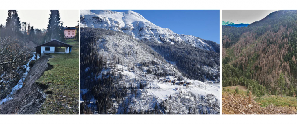
focused on classifying the danger of what are defined chain effects resulting from intense meteorological phenomena. The VAIA storm certainly taught a lot in this sense: the mapping of landslides and flooded areas carried out close to the event was certainly not exhaustive of the effects on the ground that would have been recorded in subsequent years. In fact, the felled trees have generated numerous new avalanche sites, in many cases insisting on vulnerable elements such as houses and infrastructures. Just as the trees left on the ground in order to mitigate the avalanche risk up to the completion of the defense works have increased the risk of proliferation of the Spruce Bark beetle. In the coming weeks, an example of multi-risk classification that takes into account all the phenomena that may occur as a consequence of a storm will be published on the TRANS-ALP website, thanks to a webGIS viewer. Thanks to the experience of the EURAC research center gained in this sector, the above has been further represented thanks to the conceptual model of the impact chain methodology consisting of a multi-risk analysis model capable of describing the cause-effect relationship between all factors that constitute the vulnerability of a system and analyze the climatic signals that can lead to an increase in risk. The model is a useful analysis tool for the civil protection system.

Simulation model of post-extreme instability.
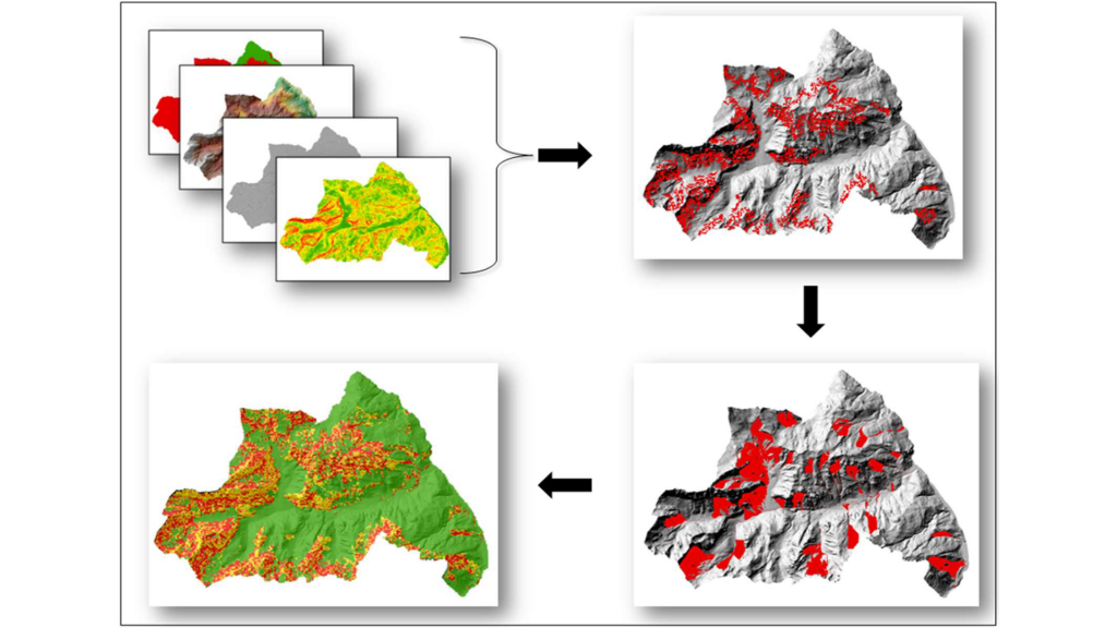
Finally, a geostatistical model was developed by the technicians of Arpa Veneto capable of simulating the propensity for instability following an event, such as that of VAIA, capable of upsetting the morphological and forest cover balances of a given territory. The model, taking into account all the morphological characteristics and vegetation cover, thanks to a specific algorithm, returns the probability of triggering of an avalanche phenomenon. Once the trigger areas have been identified, the model automatically processes the release of avalanches and calculates their trajectory on a morphological basis, also indicating which vulnerable elements may be affected by the avalanche transit. This easy-to-use tool will be of great use in the first civil protection actions following the meteorological event, in order to identify intervention priorities for risk mitigation.
Next steps
Before the end of the project, the technicians of Arpa Veneto will develop a mathematical elaboration model capable of returning, following events such as VAIA, the height values of the vegetation falled to the ground. The trees falled to the ground constitute, in fact, a first protection against the possibility of triggering of avalanches, therefore capable of mitigating the risk until the defense works are carried out; it is essential to know its height to understand how much snow must accumulate on the ground before creating a real problem for the towns below. This value then becomes the starting point in the application of the various civil protection procedures still in place today in the territories affected by VAIA. At the end of the project, an integrated tool will therefore be available capable of returning a multi-risk scenario following extreme meteorological phenomena and, at the same time, of providing tools of immediate use to support civil protection operations and procedures.

CoupEvent project workshop: Hillslope-channel coupling during extreme events
The final workshop of the project CoupEvent: Hillslope-channel coupling during extreme events will take place online on February 14th, 2022. The project has focused on interconnections among mass wasting processes and channel dynamic during extreme events in South Tyrol, a paradigmatic mountain region.
Massimiliano Pittore, the TRAN-ALP Project Manager, will present to the audience the TRANS-ALP project goals, outputs, activities and the project interdisciplinary approach.
More information about the event at this link: https://www.eurac.edu/en/institutes-centers/institute-for-earth-observation/news-events/coupevent-final-workshop
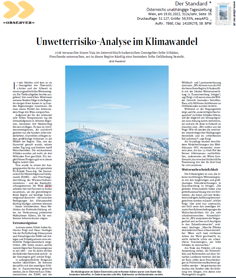
Publication on Der Standard
The Austrian newspaper Der Standard has published an article that talks about the project, its objectives and its initiatives. The article, in German, can be reached from this link.
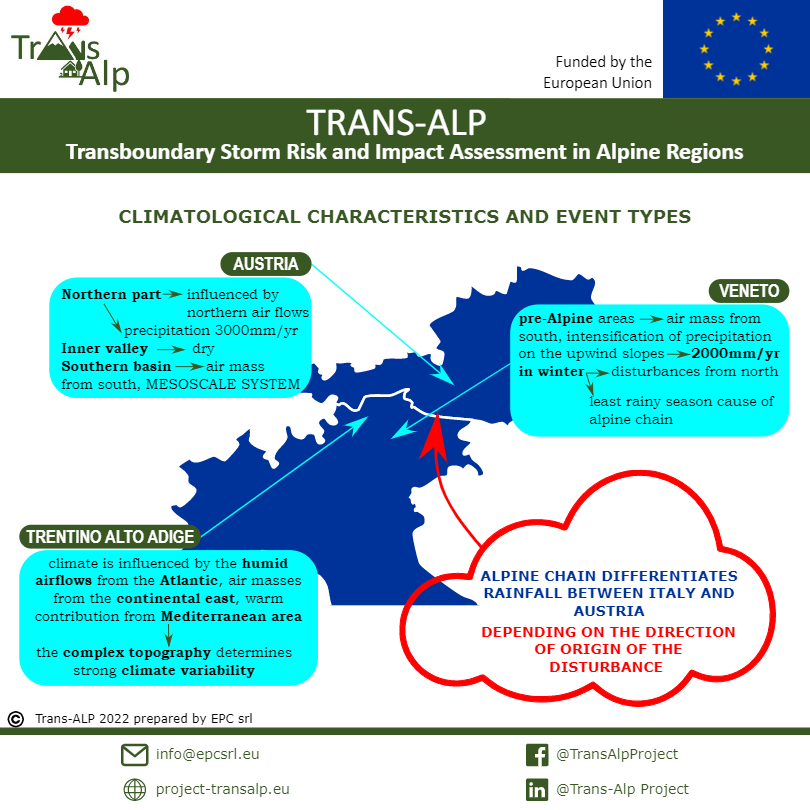
The first info-graphic of the project has been published
The first info-graphic of the TRANS-ALP project has been published. The information is related to the Deliverable 2.2 Hazard Dataset Historical Events
The Deliverable 2.2 discusses the topic of identifying storm events, which affected the border region between Austria and Italy. In particular, the focus lies on the Austrian states Carinthia and East Ty-rol as well as the Italian regions Trentino – Alto Adige and Veneto. Despite their geographical vicin-ity, all three regions exhibit different meteorological and climatological characteristics, playing an important role in terms of event identification and further analyses.
Online workshop - Recording available now
In the framework of the TRANS-ALP project, Eurac Research, with the support of EPC srl and ARPAV, organised the online workshop "Risk Governance of Severe Wheather Under Climate Change" with the aim of raising awareness and promoting discussion on the risk of severe hydro-meteorological events in the context of climate change. It was an opportunity to highlight and analyse potential similarities between past and recent disasters, such as Vaia, Central European floods and others, as examples of what could happen in the future, taking into account the latest data and estimates on climate change.
The workshop took place online in two sessions, with keynote speakers and a guided discussion.
The event, part of the All4 Climate Italy initiative, was addressed to researchers, practitioners and policy makers in the fields of risk forecasting, prevention, management, and assessment, but also to local authorities, civil protection operators, climate change researchers and the general public.
Recordings of the Workshop are available here: 30-September-2021 OnLine event – Trans Alp (project-transalp.eu)
Due to the increasingly high temperatures, the intensity of weather phenomena is also increasing in South Tyrol
This trend is set to continue, with a forecast of rising temperatures from 1 ° C to 4 ° C by the end of the century as explained by Dieter Peterlin meteorologist of the Autonomous Province of Bolzano. The latter forecast is the most problematic since the development of thunderstorms depends on various factors, such as air humidity or wind and a rise in temperatures presupposes an increase in energy in the atmosphere and the consequent development of violent thunderstorms in the Alpine arc.
The Trans-Alp project, seeks to monitor all these parameters to provide practical tools and methodologies for the prediction of cross-border impact and risk assessments to public authorities and stakeholders, so as to prevent the damage that these violent weather events could inflict on environmental and socio-economic systems in the Alpine region.
CLICK HERE to watch an interview with the meteorologist of the Autonomous Province of Bolzano Dieter Peterlin (only in italian).

Online the new Trans-Alp Project website
The increasing intensity and occurrence of extreme weather events in the Mediterranean region are likely connected to climate change and threaten vulnerable environmental and socio-economic systems.
The current risk assessment and prevention tools are still insufficient, therefore, there is an urgent need to provide local, national and European decision makers and stakeholders with improved and harmonised tools and methodologies for climate change adaptation for cross-border event.
There is a current lack of harmonised, transboundary risk assessments oriented to impact forecasting and prevention for such type of events in the Alpine regions.
The project will be implemented by a consortia of environmental, meteo-hydrological and earth observations institutes from Austria and Italy.
The project will be supported by a group of Interested Stakeholders from areas of Civil Protection, Land Management, Research and other key sectors, from Italy, Austria and Slovenia.